
20 Places to Visit in Meghalaya, Grouped by Area
20 places to visit in Meghalaya grouped by area, with altitude, distance from Shillong, best months, time needed and one honest tip for each stop.
Shillong Trip Travel Desk · Updated · 9 min read
 ANKAN · Commons · CC BY-SA 4.0
The top places to visit in Meghalaya are Shillong, Sohra (Cherrapunji) with Nohkalikai Falls and the Nongriat root bridges, Laitlum Canyons, Dawki's Umngot River, Mawlynnong and Krang Suri Falls. Base yourself in Shillong and Sohra, allow five to seven days, and visit from October to April for clear views.
Key takeaways
- Split Meghalaya into four areas: Shillong and around, the Sohra plateau, the Dawki–Mawlynnong border belt, and the Jaintia Hills.
- Five days covers Shillong, Sohra, Dawki and Mawlynnong without rushing; seven adds Nongriat and the Jaintia Hills.
- No permit is needed for Meghalaya for Indians or foreigners; hotels register every guest, so keep photo ID handy.
- Shillong Peak sits inside an Air Force area and has generally been closed to foreign nationals; Laitlum is the alternative.
- The Umngot River is glass-clear only from about November to April; in the monsoon it runs brown.
- Nongriat means about 3,500 steps down and back up; give it a full day or stay the night.
On this page 11 sections
Meghalaya has more waterfalls, caves and viewpoints than any one trip can hold, and the list you find online rarely tells you which ones sit on the same road. We group them the way our drivers do: by area, so you can see what fits into a day.
Every entry below gives altitude, distance and drive time from Shillong, the best months, permit rules, how long to allow and one tip from our own trips. None of Meghalaya needs a special permit for Indians or foreigners, but since June 2025 every hotel and homestay must register guests on the state tourism app, so keep ID with you. Registration at entry points has also been planned; check current status before you travel. For the finer print on fees and registration, see Meghalaya travel rules.
Meghalaya by area
| Area | Places in this guide | Base | Days to allow |
|---|---|---|---|
| Shillong and around | Shillong, Shillong Peak, Elephant Falls, Umiam Lake, Laitlum, Mawphlang | Shillong | 2 |
| Sohra plateau | Sohra, Nohkalikai, Mawsmai, Nongriat, Wei Sawdong, Mawsynram | Sohra | 2–3 |
| Border belt | Mawlynnong, Dawki and Umngot, Shnongpdeng, Krang Suri | Shillong, Dawki or Shnongpdeng | 1–2 |
| Jaintia Hills | Jowai, Nartiang | Jowai or Shillong | 1 |
| West and Garo Hills | Nongkhnum Island, Balpakram | Nongstoin, Tura | 2–4 |
Shillong and around
1. Shillong
Altitude: 1,525 m · From Guwahati: 100 km, about 3 hrs · Best months: October to May · Permit: none · Time: 2 nights
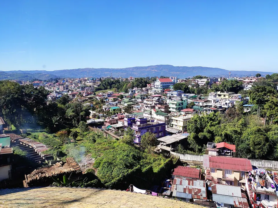
The capital is your base for most of the state. Ward's Lake, the Don Bosco Museum, Iewduh market and the cafes of Laitumkhrah fill a day easily. Read more on our Shillong page.
Tip: most shops and many restaurants close on Sunday, so plan sightseeing, not shopping, that day.
2. Shillong Peak
Altitude: 1,965 m · From Shillong: 10 km, 30 min · Best months: October to April · Permit: Indians need original photo ID at the Air Force gate; foreign nationals have generally not been allowed · Time: 1–1.5 hrs
The highest point near the city, with a view over Shillong on clear mornings. Shillong Peak sits inside an Indian Air Force area, so check current status before you travel.
Tip: go before 10 am; by noon cloud often closes in.
3. Elephant Falls
Altitude: about 1,600 m · From Shillong: 12 km, 30 min · Best months: June to November · Permit: none, entry ticket at the gate · Time: 1 hr
Three tiers of falls reached by a short stepped path. Elephant Falls pairs naturally with Shillong Peak on the same morning.
Tip: the lowest tier is the best, and the steps back up are steeper than they look.
4. Umiam Lake
Altitude: about 980 m · From Shillong: 15 km, 30 min · Best months: October to May · Permit: none · Time: 1–2 hrs
The reservoir you pass on the Guwahati road. Umiam Lake has boating, kayaking and a couple of lakeside resorts.
Tip: stop on the way up from Guwahati rather than making a separate trip back from Shillong.
5. Laitlum Canyons
Altitude: about 1,750 m · From Shillong: 22 km, 45 min · Best months: October to April · Permit: none, village parking fee · Time: half a day
A grassy ridge that drops into deep gorges, with a long stairway down to Rasong village. Laitlum Canyons is also the best viewpoint for foreign travellers who cannot enter Shillong Peak.
Tip: sunrise here beats sunset; cloud builds in the afternoon, even in winter.
6. Mawphlang Sacred Forest
Altitude: about 1,800 m · From Shillong: 25 km, 45–60 min · Best months: all year, driest October to April · Permit: none, a local guide is compulsory · Time: 1.5–2 hrs
A community-protected forest where nothing may be removed, not even a fallen leaf. The guided walk at Mawphlang explains Khasi beliefs better than any museum.
Tip: wear shoes with grip; roots and moss make the trail slippery year-round.
The Sohra plateau
7. Sohra (Cherrapunji)
Altitude: about 1,480 m · From Shillong: 55 km, 1.5–2 hrs · Best months: October to April for views, June to September for rain · Permit: none · Time: 1–2 nights
Once the wettest place on record, and still one of the wettest. Sohra is the base for the falls, caves and root bridges below.
Tip: sleep here at least one night; day-tripping from Shillong wastes four hours in the car.
8. Nohkalikai Falls
Altitude: viewpoint about 1,240 m · From Shillong: about 58 km, 2 hrs (5–7 km from Sohra town) · Best months: June to November · Permit: none, entry ticket · Time: 1 hr
A plunge of about 340 metres into a green pool. Nohkalikai is thin in March and April and at full force after the rains.
Tip: October mornings give you both good flow and a clear view.
9. Mawsmai Cave
Altitude: about 1,280 m · From Shillong: about 56 km, 2 hrs (6 km from Sohra) · Best months: all year · Permit: none, entry ticket · Time: 30–45 min
A short, lit limestone cave with one tight squeeze. Mawsmai is the easiest cave in the state for children and older travellers.
Tip: go before 10 am; tour groups create queues inside by late morning.
10. Nongriat Double Decker Root Bridge
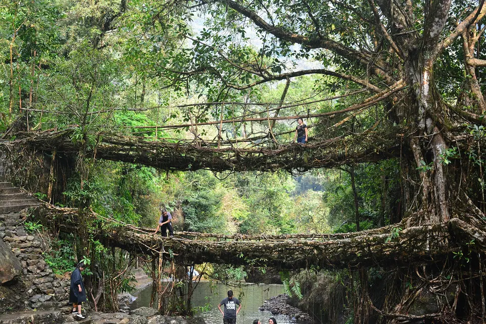
Altitude: about 600 m · From Shillong: about 65 km, 2.5 hrs to the Tyrna trailhead · Best months: October to March · Permit: none, small village fees · Time: full day, or one night in Nongriat
Roughly 3,500 steps down from Tyrna to the two-level bridge of living fig roots, then all of them back up. Our Nongriat page covers the trek.
Tip: start by 8 am, carry two litres of water and skip it after heavy rain.
11. Wei Sawdong Falls
Altitude: about 1,380 m · From Shillong: about 50 km, 1.5 hrs · Best months: October to April · Permit: none, entry fee · Time: 1.5 hrs
A three-step fall with turquoise pools, reached by a steep trail and bamboo ladders.
Tip: do not attempt the lower section in wet sandals; the rock is slick.
12. Mawsynram
Altitude: about 1,400 m · From Shillong: about 60 km, 2 hrs · Best months: June to September for rain, October to March for views · Permit: none · Time: half a day
Sohra's rival for the wettest-place title. Mawjymbuin Cave, with its natural stalagmite formation, is the main stop.
Tip: it makes a quieter alternative to Sohra on a monsoon trip.
The border belt
13. Mawlynnong
Altitude: roughly 800 m · From Shillong: about 80 km, 2.5–3 hrs · Best months: October to April · Permit: none, village entry and parking fee · Time: half a day
The village known for cleanliness, with a sky-view bamboo tower and the Riwai root bridge 3 km away. See our Mawlynnong page.
Tip: arrive before 10 am on weekends; by noon the lanes fill with day-trippers.
14. Dawki and the Umngot River
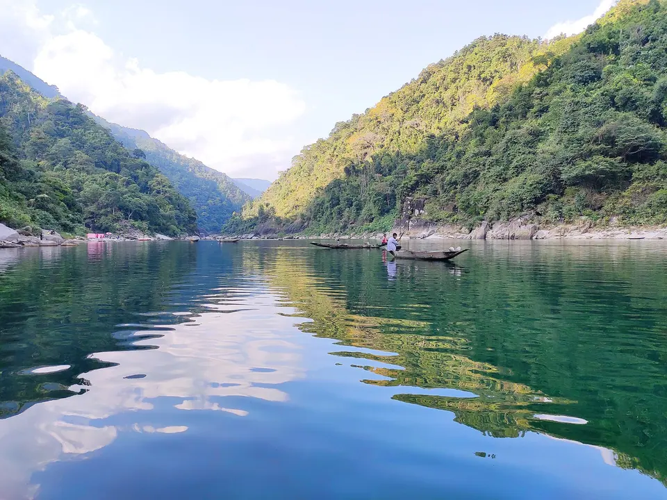
Altitude: under 100 m · From Shillong: about 85–95 km, 2.5–3 hrs · Best months: November to April · Permit: none, boats priced per boat at the ghat · Time: half a day to one night
The river so clear that boats seem to float on air, right at the Bangladesh border. Dawki is at its best in winter.
Tip: from June to September the water turns muddy, so do not build a monsoon trip around it.
15. Shnongpdeng
Altitude: under 100 m · From Shillong: about 95 km, 3 hrs · Best months: November to April · Permit: none · Time: one night
Upstream from Dawki, with riverside camps, kayaking, cliff jumping and snorkelling.
Tip: it is quieter than Dawki ghat for a boat ride, and the camping is simple but fun.
16. Krang Suri Falls
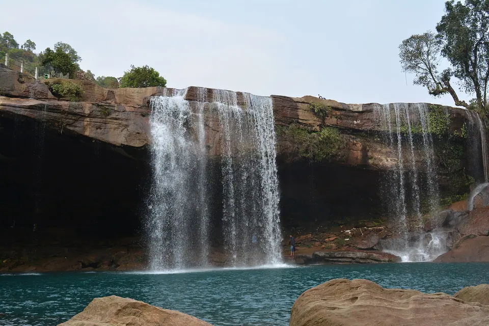
Altitude: about 800 m · From Shillong: about 90–100 km, 3 hrs · Best months: October to May · Permit: none, entry fee and life-jacket hire · Time: 2 hrs
A blue pool below a curtain fall in the Jaintia Hills. Krang Suri may close in heavy rain, so check current status before you travel.
Tip: swim only with a life jacket; the pool is deeper than it looks.
The Jaintia Hills
17. Jowai
Altitude: about 1,380 m · From Shillong: 64 km, 2 hrs · Best months: October to April, plus July for Behdienkhlam · Permit: none · Time: one night
The Pnar heartland, with the Myntdu river, Thadlaskein lake and the July Behdienkhlam festival. See our Jowai page.
Tip: pair it with Krang Suri and Nartiang for a two-day loop.
18. Nartiang Monoliths
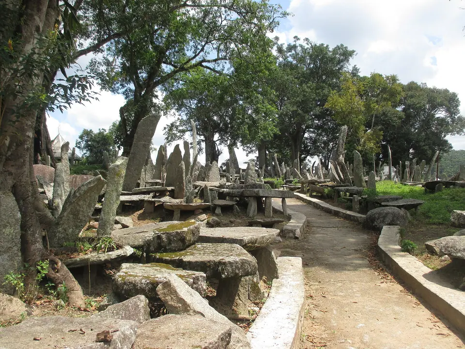
Altitude: about 1,300 m · From Shillong: about 65 km, 2 hrs · Best months: all year · Permit: none · Time: 1 hr
A field of standing stones, the tallest around 8 metres, raised by the Jaintia kings.
Tip: the Durga temple nearby is worth ten minutes on the way out.
West Khasi and Garo Hills
19. Nongkhnum River Island
Altitude: roughly 600 m · From Shillong: about 100–110 km, 3.5–4 hrs · Best months: November to April · Permit: none · Time: one night
A large river island near Nongstoin, with sandy banks and the Langshiang Falls nearby.
Tip: carry food and cash; services on the island are basic.
20. Balpakram National Park
Altitude: about 900 m · From Shillong: 300+ km; base at Tura or Baghmara · Best months: November to March · Permit: entry permission from the forest office · Time: 2–4 days including travel
A plateau and canyon in the south Garo Hills, sacred in Garo tradition. Balpakram is for travellers who want wilderness over comfort.
Tip: go with a local guide; signage and phone signal are almost nil.
Worth a stop if you pass
These did not make our numbered list, but they sit on roads you will already be driving:
- Seven Sisters Falls (Nohsngithiang) near Mawsmai: a row of falls off one cliff, best from July to October and often just rock face in March
- Arwah Cave above Sohra: longer than Mawsmai, with fossils in the walls and a paved approach
- Dainthlen Falls on the Sohra road: flat rock shelves above the drop, good for a quick photo stop
- Mawkdok Dympep valley viewpoint: the first big valley view on the Sohra road, with a zipline
- Don Bosco Museum in Shillong: seven floors on the cultures of the Northeast, with a rooftop skywalk
Getting between the areas
Meghalaya's distances look short on a map, but hill roads, trucks at Dawki and weekend traffic in Shillong stretch them. Allow roughly 25–35 km per hour of driving outside the city. A private car with driver from Shillong costs more than shared taxis, but it is the only practical way to string three or four stops together in a day. Since June 2025, renting private vehicles to tourists for self-drive has been prohibited in Meghalaya, so plan on a car with a local or Guwahati driver.
The roads connect like this. Sohra is a dead end off the Shillong plateau, so you come back the same way. Mawlynnong and Dawki share the Pynursla road south-east of Shillong. Krang Suri is reachable from Dawki via Amlarem, which saves going back to Shillong, but that link is narrow and slow in rain. Jowai sits on the Silchar highway east of Shillong, and the west Khasi and Garo Hills need their own trip.
Fees, cash and signal
There is no statewide tourist entry fee, but almost every waterfall, cave and village viewpoint charges a small entry, parking or camera fee, typically under INR 100 per person. Umngot boat rides at Dawki are priced per boat, so agree the fare at the ghat. Village councils run most of them, and many collect in cash only. Keep INR 1,000–1,500 per person in small notes for a day of sightseeing. Card and UPI work in Shillong and most Sohra hotels, but mobile data drops away around Dawki, Nongriat and the Jaintia back roads.
Which places suit your trip
| Trip length | What fits | Our package |
|---|---|---|
| 3 days | Shillong, Laitlum, Sohra, Nohkalikai | Shillong and Cherrapunji |
| 4 nights | Shillong, Sohra, Dawki, Mawlynnong | Shillong, Cherrapunji, Dawki and Mawlynnong |
| 5 nights | Add the Nongriat trek | Living Root Bridges Trek |
| 6 nights | Add Laitlum, Krang Suri and a slower pace | Complete Meghalaya |
Month matters as much as days. Our best time to visit Meghalaya guide covers rain, fog and river clarity month by month.
How we'd plan it
For a first trip of five to six nights, we use two bases. Two nights in Shillong cover the city, Laitlum and Mawphlang. Two nights in Sohra cover Nohkalikai, Mawsmai and the Nongriat trek with a free morning after. A final day runs to Mawlynnong and Dawki, with a night by the river or back in Shillong.
That is the shape of our Shillong, Cherrapunji, Dawki and Mawlynnong trip. Walkers should look at the Living Root Bridges Trek, and anyone with a week should take Complete Meghalaya.
Send us your dates on the contact page and we will match these places to the days you have.